Despite some overnight rain and cooler conditions, Northwestern Ontario entered Tuesday with 140 active wildland fires, 47 not under control, six being held, seven under control and 80 being observed.
The largest fires remain concentrated in the Thunder Bay-Ignace corridor, with several new starts recorded in the Fort Frances fire sector on Monday, including two listed as not under control, according to Ontario Forest Fires. The entire Northwest remains under a restricted fire zone designation, prohibiting all outdoor fires including campfires, brush burning, fire pits and charcoal barbecues.
Environment Canada warned that strong winds and possible thunderstorms on Tuesday could contribute to unpredictable fire behaviour. Gusts of 60 to 70 km/h are expected in parts of the Northwest, and smoke conditions may worsen across the Rainy River District depending on wind direction.
“Precipitation and thunderstorms are forecasted for the next few days,” Ontario Forest Fires (OFF) said in a release. “A large number of lightning strikes have been observed across the landscape. The fire hazard is low across the Northwest Region today, but potential for new fire starts from lightning remains.”
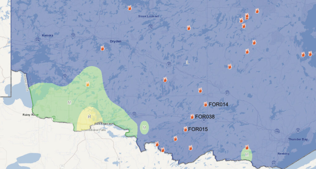
The largest fires near Fort Frances remained concentrated in the Atikokan Cluster—Fort Frances 14, Fort Frances 15 and Fort Frances 38, according to OFF.
The most significant fire affecting the region is Fort Frances 14, a massive blaze just northeast of Quetico Provincial Park straddling the western and northern shores of Lac des Mille Lacs that is now bigger than 50,000 hectares.
That fire continues to drive evacuation orders for Baril, Bedivere, Windigoostigwan and Lac des Mille Lacs, while a wide swath of surrounding townships remains under evacuation alert. Residents in those areas have been warned to be prepared to leave with little notice.
“Firefighting crews from Ontario and Alberta are assigned to the cluster of fires, supported by bucketing helicopters targeting hotspots,” OFF said. Fort Frances 15, south of Highway 11 in Quetico Provincial Park, has been remapped to a smaller, more accurate size of 41,800 hectares but is not under control. “There has been no growth on either fire perimeter in the direction of major travel corridors,” OFF said.
Fort Frances 38, north of Crystal Lake, is now under control, covering 44 hectares.
“Favourable weather conditions have helped to reduce fire behaviour, allowing for crews to make good progress on the fire line,” OFF said.
The agency also said Monday that the Pan Canadian Aerial Asset Program (PCAAP), managed by the Canadian Interagency Forest Fire Centre (CIFFC), has sent two Q400 airtankers, twin-turboprop aircraft with an external tank that can drop water, foam or fire retardant and a “birddog,” a spotter aircraft that flies ahead of airtankers to identify targets.
Three new Fort Frances–area fires were reported late Monday by the Ministry of Natural Resources and Forestry (MNR); Fort Frances 42, located northeast of Atikokan near Dunnet Lake, was declared out at 0.1 hectares. Two others—Fort Frances 43, northwest of Crowrock Lake, and Fort Frances 44, east of Highway 502 near Laver Lake—were each measured at 0.1 hectares and remain not under control. Although small, the new starts reflect the broader pattern of lightning‑driven ignitions across the district as unstable weather continues.
The OPP said Monday they continue to assist the MNR with evacuations and road‑safety operations across the Northwest.
Highway 599 reopened at 11 a.m. Monday after several days of closure between Highway 516 and Mishkeegogamang First Nation, though officials warned it may have to close again without notice if conditions deteriorate. Highway 527 at Gull Bay First Nation remains closed except for limited local evacuation traffic. Drivers are being urged to use extreme caution, as smoke has reduced visibility on several northern routes.
The OPP emphasized that wildfires remain dynamic and unpredictable, with fire behaviour capable of shifting rapidly due to wind and weather. The public are asked to stay away from evacuated areas, avoid non‑essential travel in affected zones and follow all instructions from emergency officials. Unauthorized entry into evacuated areas may result in charges, including a $110 fine and three driver’s licence demerit points for failing to comply with road‑closure signage.
To support the wildfire response, the OPP has deployed Aviation Services, the Emergency Response Team, the Provincial Liaison Team and additional operational support units. Officers are assisting with evacuations, enforcing closures and helping ensure public safety as conditions evolve.
Ontario continues to deploy significant resources to the Northwest, with more than 150 fire crews and over 80 aircraft assigned across the region. Additional support has arrived from Alberta and Yukon, and federal assistance remains available if required. Thousands of evacuees are being hosted in communities across the province, including Thunder Bay, Kenora, Sioux Lookout, Red Lake, Sudbury, Niagara Falls, Toronto and others.