

Even as cooler temperatures arrive in the northwest, much of the region is still under high to extreme wildfire conditions, with five new fires reported yesterday, bringing the total number of active wildfires in the region to 14, according to the Ontario government’s Forest Fire Info Map.
Currently of note in the region, FOR004, which is burning along Highway 11 near Crystal Lake and Sapawe Lake, is listed as Not Under Control at a size of 3,233 hectares. The fire has prompted an evacuation alert from the Ministry of Natural Resources for those living in the area, warning that due to the fire’s evolving situation and increasing behaviour, anyone with a home or cabin in the area of the fire should be prepared to evacuate on short notice.
“This includes all areas accessed by Camp 111 Road and Crooked Pine Road (Blalock Road), Nydia Lake, Eva Lake, Kawene Lake, Marion Lake, Marion Lake Road, Crystal Lake, all roads accessing Crystal lake, Niobe Lake, Nickleby Lake Road and Nickleby Lake, Sapawe Lake, Sapawe Mill, Sapawe Road, Sapawe/Upsala Road, Premier Lake Road, Marmion Lake – Reserve Island, Marmion Lake – Hoist Camp Narrows, Marmion Lake – Reserve Bay, Osinawi Lake, Pipeline Road, Sawbill Road, Cloven Road, Pinecone Road, Caldwell Road and Hardtack Road,” the Ministry said.
In the event of an evacuation order, the Ministry warns all affected residents to plan ahead and stay connected.
- Make sure you are aware of the current fire situation
- Prepare an emergency bag with your essentials (medicine, passports, legal documents etc.)
- Monitor official channels for updates at ontario.ca/fireupdates
- Be ready to quickly leave if instructed
- Respect evacuation orders, road closures and public officials direction
- Give crews and aircraft ample space to work
- Forest, wildland and outdoor fires
- Learn about forest and wildland fire activity, restrictions, management, safety and prevention.
The Ministry of Natural Resources warns that heavy smoke from the fire has caused visibility issues for aircraft working over the area, though helicopter bucketing operations were ongoing yesterday. As of the last update, there are eight FireRanger crews assigned to the fire, with supression efforts focussed on the south end of the fire and values protection on the north end.
Northwards, the biggest wildfire in the region sits along the Ontario and Manitoba border. KEN020 started on May 12, 2025, and is now burning at 23,281 hectares. The fire’s status is Not Under Control, and has prompted an implementation order for the area along the border.
“An implementation order is now in effect around active wildland fire Kenora 20 in the Kenora sector to protect public safety and facilitate effective fire suppression,” the Ministry states.
“All travel and use of roads, including Gundy Road north of Tannis Lake, Pickerel Lake Road beyond the Pelicanpouch access point at km 9, and Cygnet Lake Road, is prohibited unless authorized by a travel permit. All use of lakes and waterways within the Area including the Winnipeg River below Whitedog Falls, Eaglenest Lake, Tetu Lake, Cygnet Lake, Rice Lake, Malachi Lake, Otter Lake, Macara Lake, Longpine Lake, and Dagimabrop Lake is prohibited.”
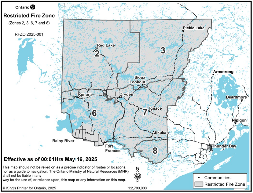
Due to the heightened risk of fires in the region, the province will be implementing a restricted fire zone across much of the region, encompassing all of Provincial Zones 2, 3, 6 (which includes Rainy River to Fort Frances), 7 (which includes the easter portion of the Rainy River District) and 8 (Quetico Provincial Park). The restricted fire zones come into effect Friday, May 16, 2025 at 12:01 a.m. local time.
“The area impacted will be from the Southwest corner of the USA, Manitoba and Ontario border, North along the Manitoba border to West of the midway point of Weeskayjahk Ohtahzhoganeeng Provincial Park, East to North of Wabakimi Provincial Park, South along the Western border of Wabakimi Provincial Park to the Eastern border of Quetico Provincial Park until the USA border, then back West along the USA/Canada border to the Manitoba Border,” the Ministry said.
“Outdoor fires will be banned. Portable gas stoves may still be used BUT must be handled with extreme care.”
To see more of the wildfire situation in Ontario, visit the province’s live Forest Fire Info Map, or follow Ontario Forest Fires on Facebook.


